
Scotland's Finest Scenic Routes
My personal favourites.
Scenic routes that are an absolute delight with landscapes that are awe inspiring, off the charts or just.....very pretty. In essence these are routes for cars, but rest assured, travelers on foot or on a bike will find them very gratifying as well.
Hardknott Pass (5 km) from Cockley Beck Bridge to the River Esk
Starts from Plus code: CR3Q+W6J Broughton-in-Furness / Region: Cumbria
This very scenic route is not even in Scotland but it's close enough. However.....please, think before you go! Hardknott Pass is not an easy road to travel. Many tight hairpins and percentages of 30-33% (!!). Not for big campervans and certainly not for inexperienced drivers. To get to the beginning of the pass you might want to start out from Ambleside. Follow the A593 to Clappersgate and the B5286 to the 'Drunken Duck Inn' at Barngates where you turn sharp right on Bog Lane. At Skelwith Bridge turn left on the A593. After a few kms turn right direction "The Langdales" (the small sign is difficult to see!). It is still quite a long (but exquisite) drive untill you finally get to Cockley Beck Farm where the road crosses a bridge and you see the sign for Hardknott Pass. If you're interested, there are remains of a Roman fort after 3 kms!
Maybe interesting to explore:

- The Trossachs Trail (60 km) from Aberfoyle back to Aberfoyle
Starts from Plus code: 5JH8+F39 Aberfoyle, Stirling / Region: Loch Lomond, Stirling & The Trossachs
But you can of course start from any point along this beautiful trail.
There is (at the moment) no GPX file, but here is a link to a specific page on the Trossachs Trail website where you'll find a map: The Trail
A (hopefully) leisurely drive through this beautiful part of Scotland. The trail is signposted! From Aberfoyle follow the A821 (11 km) stretch of the Duke's Pass to Kilmahog where you turn right (A84) towards Callander and Doune. Continue on the A84 (6 km) to Blair Drummond untill you reach the turn off for Aberfoyle (A873). Roughly 40 km later you'll arrive back at your starting point. Do check out The Trail for all the interesting places along this trail.
- Knoydart. Off the Main Road Route (36 km) from Glen Garry to Kinloch Hourn
Starts from Plus code: 33MX+9HH Roy Bridge / Region: Isle of Skye & Kyle of Lochalsh
West of Invergarry (about 8 km) there is a turn off from the A87 for Kinlochourn. From there the narrow road follows the wooded shore of Loch Garry and reaches the tiny hamlet of Inchlaggan after 7,2 km. After Inchlaggan the road still leads through wooded terrain but, as you get closer to Loch Poulary, everything changes dramatically. More space, less trees and in the distance you'll notice faintly some mountaintops. You are going to love this! Wide open vista's and a road that weaves from left to right heading for Loch Guoich and the bridge.
After the bridge the landscape is even more stunning and feels even more lonely. Just get out of the car and experience the silence. It's magic! You're in the 'wilds' of Knoydart now. Good to know there is a wonderful B&B and Tearoom (Lochhournhead B&B) at the very end of this route. Once there you might consider leaving the car at the car park and go for a brisk walk. So many trails are just waiting to be discovered. You could even 'jump' on the famous Cape Wrath Trail. (only for diehards!)

- Heart of the Borders Route (46 km) from Moffat to Tweedsmuir
Starts from Plus code: 8HJ4+VG Moffat / Region: Dumfries & Galloway
A fine scenic route crossing the very heart of the Borders. Start from delightful Moffat on the A708 direction Selkirk. This is a wonderful 27 km drive. Halfway along St Mary's Loch at Cappercleugh you turn left on a very nice and stunningly bleak drive towards Tweedsmuir (19 km). Before you get to Tweedsmuir you'll pass the Megget reservoir and the equally impressive Talla Reservoir.
Maybe interesting to explore:
A little secret?: The Gordon Arms Yarrow
A pleasant restaurant (with rooms!) just a few more km past Cappercleugh at Mountbenger. There is a blog here.

- Just Another Borders Route (87 km)
Starts from Plus code: 5253+M77 Langholm / Region: Dumfries & Galloway
The south of Scotland has so much to offer. This is an area often neglected as the world famous Scottish Highlands are always calling from afar. Yes, it's true that I'm very much a lowland fan (although I love the Highlands as well!) and so I feel this "Just Another Borders Route", starting out from Langholm, is a much needed enticing example of what the region has to offer the discerning traveler. You might be in for a surprise! Whatever you do....don't rush it! Enjoy!
Maybe interesting to explore:

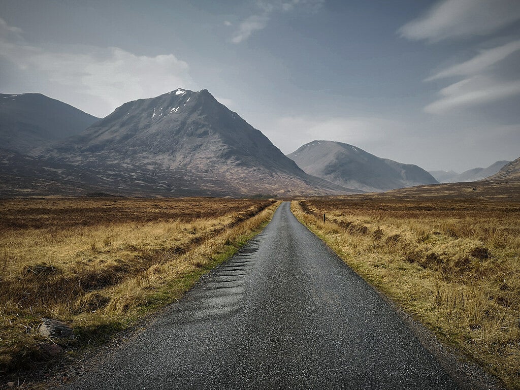
- Glen Etive Scenic Abundance (20 km)
Starts from Plus code: M43Q+H9H Ballachulish / Region: Fort William, Ben Nevis & Lochaber
The turning is signposted off the A82 between Glencoe and Bridge of Orchy. This may be a short drive (only 20 km), but it would be such a shame if you were to miss out on this more than stunning experience. Winding through heather-covered moorland following the river Etive with small waterfalls and deep forest with many a bend uncovering even more beauty, this drive will leave you breathless. For some more detailed info: https://www.ontheluce.com/glen-etive-road-scotland/
- Glen Roy and the Braeroy Road (27 km)
Starts from Plus code: V5R5+C65 Roy Bridge at Roybridge / Region: Fort William, Ben Nevis & Lochaber
This very pretty single track route starts out from Roy Bridge and runs up Glen Roy to 'finish' at Turret Bridge. The route takes you through the Nature Reserve and the views are outstanding. Personally I thoroughly enjoyed this trip. More than worth it!
You can get a lot farther if you're up for it, but it is not a through road! Eventually you have to return to Roybridge
Maybe interesting to explore:

- Ardnamurchan, Remote and Beautiful (50 km)
Starts from Plus code: PQC7+JR Fort William / Region: Fort William, Ben Nevis & Lochaber
Ardnamurchan (Àird nam Murchan) translated as "Headland of the Great Seas", feels truly as the end of the known world and very much off the grid.
The peninsula with it's narrow winding roads, some ruined castles, and wide open skies has a sense of utter remoteness. A great place to get away and 'loose' oneself.
Start from Corran. The ferry takes you in a few minutes to Ardgour. From Ardgour follow the A861 south to Inversanda. Once there turn left on the B8043 if you like stretches of utter remoteness, or continue on the A861 for more wooded scenery, villages and great coastal routes (Strontian, Salen, Acharacle). THIS scenic trail however turns left! Follow the B8043 untill you get to the A884. Turn left for Lochaline and the ferry (Plus code: G6PF+GJ Morvern, Oban) to Mull, another treasure!
Maybe interesting to explore:

- Quintessential Assynt (90 km)
Starts from Plus code: VRWW+M33 Ullapool / Region: Caithness, Sutherland & Ross
This route is 'more or less' part of the 'famous' NC500 (more on that further below)
This route is a must: From pleasant Ullapool to 'far away' Kylesku runs the Quintessential Assynt Route. There is absolutely nothing official about it. This route originated from my very own 'memory vault'. Skirting small lochans, winding around low lying hills the route enters and leaves (after a stroll with coffee and a pastry maybe) the town of Lochinver to continue, seemingly with wild abandon, towards the bridge at Kylesku.....and that's by no means the end of it.
From Ullapool take the A835 north to Drumrunie. At Drumrunie turn left for "Achiltibuie And The Summer Isles". The road soon follows the shores of Loch Lurgainn and Loch Ad a' Ghaill. Shortly thereafter turn right for Lochinver. Roughly 19 wonderful km to Lochinver. After Lochinver follow the A837. Soon you'll get to the turn off for Drumbeg (A869). You'll love it! At Drumbeg the A869 continues on and finally connects with the A894. Turn left for Kylesku.
After Kylesku this great route continues al the way to Durness and the far north. Why not do the same!
Maybe interesting to explore:

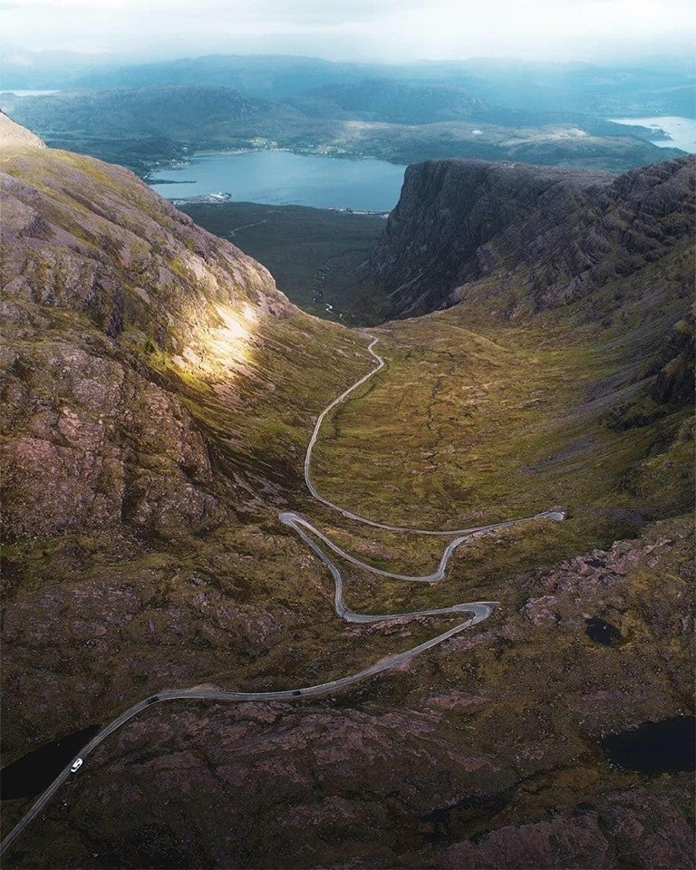
- Bealach na Ba (18 km and 57 km for the 'full' trip)
Starts from Plus code: C99W+9W2 Tornapress, Strathcarron / Region: Isle of Skye & Kyle of Lochalsh
This route is part of the 'famous' NC500 (more on that further below)
The Bealach na Ba ("Pass of the cattle") is the highest pass in Scotland and a great drive in its own right. The route (with passing places!) starts at Tornapress and, after many hairpins, finishes at the most delightfull village of Applecross. The only option than is to turn back or, much better, to continue along the coast to the picturesque village of Shieldaig (total: 57 km)
I've done this route quite a few times and it is a fantastic drive along one of the most dramatic roads on mainland UK with terrific views (if there's no fog!) across much of Wester Ross, the Isle of Skye, and the Islands of Rum and the Outer Hebrides.
A serious warning: If you have a caravan in tow, or are driving a large motorhome, or are an inexperienced driver, you should definitely NOT attempt it! There is a warning sign at the beginning of the road at Tornapress and you might want to think twice at this point! This is not scaremongering, this is FACT.
- Maybe interesting to explore:
- Torridon Area Of Outstanding Natural Beauty

- A Roaring Silence (60 km via Forsinard or 100 km via Altnaharra)
Starts from Plus code: 3694+CXW Helmsdale / Region: Caithness, Sutherland & Ross
This route is 'more or less' part of the popular NC500. More or less because it takes you away from the 'official' route and offers you a fantastic alternative drive! (more on the NC500 further below)
For a wide open rather bleak landscape and a 'roaring silence' this route is out of this world!
Just 7,6 km past Brora, travelling on the A9, you reach Lothbeg and the sign for Glen Loth. Turn left and follow this road all the way (15,5 km) until just past Kildonan station. Left on the A897 and after 12 km you'll get to Kinbrace:
Either continue on the A897 or turn left on the B871.
A897: After 12,5 km you arrive in Forsinard and the magnificent Forsinard Flows Nature Reserve. Another 21 km and you turn either right (A836) for Thurso or turn left for Bettyhill, Tongue and Durness.
B871: A beautiful 25 km to Syre and another 18 km on the B873 to Altnaharra. From there follow the sign for Hope (33,5 km), where you connect to the A838.
Maybe interesting to explore:

And than there are.....
.....the other routes & trails. Details are to be found at: https://www.visitscotland.com/see-do/tours/driving-road-trips/routes/planner/overview/
North Coast 500 (805 km)
The North Coast 500 was created as a Scottish equivalent of the iconic American Route 66. It has become very (way too!) popular, especially in the summer and you really should book accommodation in advance, including caravan parks. Take your time, don’t rush it, stop off in the villlages, talk to the people, and explore some of the smaller roads.
The NC500 is in essence a number of interesting places to visit. Study the map, plan your stops and how to get off the beaten track. Rather than heading north on the A9 from Inverness all the way to John o'Groats, you're better of taking the A897 from Helmsdale to Melvich, a lonely route through the Highlands. On the way south visit Lochinver, stop for a couple of days in Gairloch or Poolewe and go for a walk in the hills. The NC500 passes through breathtaking landscapes and that is, in my opinion, the main attraction.
Here are a few fantastic sites for additional information:
- https://www.northcoast500.com/explore-the-route/
- https://www.alongdustyroads.com/posts/2016/6/27/guide-things-to-know-driving-the-north-coast-500-nc500-scotland-planning
- https://independenttravelcats.com/north-coast-500-road-trip-planning-guide-nc500-route/
- https://www.dayinsure.com/news/scotlands-north-coast-500-a-comprehensive-guide/
Maybe an Idea to combine the NC500 with the Moray Firth Route and/or the Snow Road Scenic Route (no snow from March-November!)?
Bealach na Ba (Pass of the cattle)
Angus Coastal Route (109 km)
The Angus Coastal Route runs from Dundee to Aberdeen, passing a range of charming towns, beautiful nature reserves and more than a few great attractions. Enjoy great views of the Grampian Mountains to the west and the North Sea to the east as you drive north.
Additional information: https://www.wanderlustlaura.com
Go and see: Arbroath Abbey, St Cyrus National Nature Reserve, Dunnottar Castle.

A colourful display
Argyll Coastal Route (208 km)
Set off from the banks of Loch Lomond to explore Scotland’s west coast and travel the Argyll Coastal Route route from Tarbet to Fort William. Discover Loch Fyne, the fascinating history of the Kingdom of Dalriada and the astonishingly diverse landscapes – from sea shores to mountain top.
Go and see: Inveraray Castle, Inveraray Jail, the Auchindrain Township, Kilmartin Museum, Dunadd Fort, Castle Stalker, Glen Coe and Ben Nevis.
Interested? Check out: https://www.tartanroad.co.uk/home/itineraries/argyll-coastal-route/

Last rays of the day
Borders Historic Route (143 km)
The Borders Historic Route picks up near Carlisle before passing into the lush countryside of the Scottish Borders. Follow the route to Edinburgh and explore the charming villages and many a historic site you pass en route before reaching Scotland’s historic capital city.
Go and see: Gilnockie Tower & Reiver Centre, Johnnie Gilnockie's Grave, Melrose Abbey, Scott's View, Dryburgh Abbey, Borthwick Castle, Crichton Castle and the many attractions and sites of Edinburgh itself.

Scott's View
Clyde Sea Lochs Trail (104 km)
The Clyde Sea Lochs Trail takes you into the heart of the coastal communities to the south west of the Loch Lomond & The Trossachs National Park. This established driving route is well sign posted and easy to follow, with panels packed with information located at each of the points of interest along the way, all with good car parking nearby. Start the route in Dumbarton or further north in Arrochar, with plenty to explore in between.

Stunning!
Clyde Valley Tourist Route (61 km)

Craignethan Castle
Deeside Tourist Route (174 km)
A wonderful route from Perth to Aberdeen, via the towering splendour of the Cairngorms National Park. The Deeside Tourist Route is an great drive, passing through the fruit-growing farmland of Blairgowrie, the jaw-dropping National Park and the lush landscapes of Royal Deeside.

The magnificent Cairngorms
Fife Coastal Route (124 km)
The Fife Coastal Route follows the glittering Firth of Forth coastline, passing places such as the Royal Burgh of Culross, the beautiful fishing towns in the East Neuk and historic St Andrews.

A Fife fishing village
Forth Valley Tourist Route (69 km)
Wind your way along the Firth of Forth, through West Lothian and into the Forth Valley on this excellent alternative route to Stirling, a city that’s bursting with fascinating history. Explore locations such as the Forth Bridge and Antonine Wall, which are both World Heritage Sites, the impressive metalwork of The Kelpies by Andy Scott and the fascinating engineering feat that is The Falkirk Wheel.

Forth Bridge
Galloway Tourist Route (148 km)
This is a delightful route from Gretna to Ayr. Stop off at superb attractions, including Threave Castle and the Robert Burns Birthplace Museum. There’s also ample opportunity for adventure with woodland trails to explore on foot or by mountain bike and the waters of Loch Ken for a whole range of thrilling watersports.

The Ayrshire coast
Highland Tourist Route (187 km)
If history is your 'thing', this route is a real treat. It takes in no less than four castles as well as Culloden Battlefield and many museums along the way. Nature lovers and active types will also be enthralled as the route travels through the beautiful Cairngorms National Park.

Battle site of Culloden
Moray Firth Route (128 km)
Enjoy the wild beauty of the North Highlands on this meandering route from Inverness to Loch Fleet, via the glittering waters of the Beauly Firth, Cromarty Firth and Dornoch Firth. You’ll pass through the rugged landscapes of Easter Ross and Sutherland, two of the most breathtaking and untouched parts of the country.

Beauly Priory
North East 250 (402 km)
This circular touring route combines the whisky distilleries of Speyside with the incredible mountain passes of the Cairngorms National Park, the castles of Royal Deeside and the Aberdeenshire coastline. Explore the picturesque villages along the Moray Firth Coast, wander through the historic streets of Aberdeen and make sure you uncover the fascinating history in the many attractions and castles along the North East 250.
Interested? Check out: https://www.northeast250.com/

Speaks for itself I think!
North and West Highlands (254 km)
The North and West Highlands route (actually the most interesting part of the NC500) links Ullapool with John O’Groats and passes through the stunning North West Highlands. On the route you’ll be treated to some of the most spectacularly wild landscapes in Scotland, complete with panoramic sea views, tranquil lochs and towering mountains.

WoW!!!!!!!!!!!
Perthshire Tourist Route (69 km)
The Perthshire Tourist Route kicks off just north of Dunblane and finishes in Ballinluig. It's a short but spectacular drive through the woodland and towering landscapes in the heart of Scotland. Watch as the peaceful cultivated landscape changes dramatically just north of Crieff, where you’ll find the heather covered slopes of the rugged Sma' Glen.

Black Linn waterfall
Snowroads (144 km) (no snow from March-November!)
This route shows you some of the most scenic points in beautiful Perthshire, Aberdeenshire, Moray Speyside and the Highlands. Mountains, rugged glens, towering Munros, outdoor adventures, cycling, delicious food and drink and more. The Snow Roads Scenic Route encompasses some of the Cairngorms National Park’s finest areas. Starting in the picturesque market town of Blairgowrie, the route passes through the towns of Braemar, Ballater, and Tomintoul before finishing in Grantown-on-Spey.
Interested? Check out this dedicated site: https://www.snowroads.com/

Corgarff Castle
South West Coastal 300 (482 km)
The South West Coastal 300 takes in miles of beautiful coastline along quiet country roads, with hidden gems and stunning scenery along every curve of the tarmac. Sheltered sandy bays, rocky stretches and charming coastal towns can all be found on this road trip.
The circular route follows roads along the coast of Dumfries & Galloway and into southern Ayrshire and one of Scotland’s forest parks – the Galloway Forest Park. It’s the perfect way to discover the unique character of the south west of Scotland, with many places to stop and uncover fascinating heritage, stunning natural beauty and unique experiences.
Interested? Check out: here!
Galloway Forest Park